


Our region
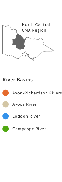
View iMapOur region is an area of diverse landscapes and land-use that covers 13% of the state.
It is bordered by the mighty Murray River to the north, which injects life into the land around it, the Great Dividing Range and Wombat State Forest to the south and Mt Camel Range to the east.
The region's main waterways are the Campaspe, Loddon, Avoca and Avon-Richardson rivers, which form part of the Murray-Darling Basin.
Avon
River Richardson
River Avoca
River Loddon
River Campaspe
River Avoca Bealiba Bendigo Boort Castlemaine Clunes Cohuna Daylesford Donald Inglewood Kerang Lake Charm Maryborough Mitiamo St Arnaud Swan Hill Wycheproof Creswick Echuca Heathcote Kyneton Trentham Macedon
River Richardson
River Avoca
River Loddon
River Campaspe
River Avoca Bealiba Bendigo Boort Castlemaine Clunes Cohuna Daylesford Donald Inglewood Kerang Lake Charm Maryborough Mitiamo St Arnaud Swan Hill Wycheproof Creswick Echuca Heathcote Kyneton Trentham Macedon
Projects in Avon-Richardson Rivers:
Projects in Avoca River:
View All >
Projects in Loddon River:
Projects in Campaspe River:
Our projects
View all projectsRivers and Wetlands
learn more Rivers and WetlandsBiodiversity
learn more BiodiversityProject Archive
learn more Project ArchiveStay up to date
Contact usNews

Unplug and Play winners announced
2 May 2024


Catch a carp and have a great family day out
17 Apr 2024

Current Flows
The North Central CMA manages water for the environment flows to a range of regulated rivers, wetlands, swamps and lakes across our region.
Keep up to date with the current flows in your area here.
Keep up to date with the current flows in your area here.Get involved
Landcare
Read more LandcareWaterwatch
Read more Waterwatch